


Sentier des Diots

cron
User

Length
11 km

Max alt
1176 m

Uphill gradient
345 m
Km-Effort
15.6 km

Min alt
946 m

Downhill gradient
346 m
Boucle
Yes
Creation date :
2024-03-06 10:05:00.456
Updated on :
2024-03-06 10:07:02.739
3h32
Difficulty : Medium

FREE GPS app for hiking
 SityTrail
IGN / Geographical institutes
SityTrail Plus
The world is yours!
About
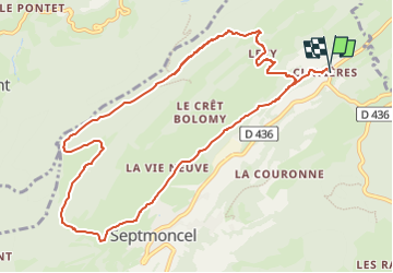
Trail Walking of 11 km to be discovered at Bourgogne-Franche-Comté, Jura, Septmoncel les Molunes. This trail is proposed by cron.
Description
parcours entièrement balisé. Pas obligatoirement besoin de carte.
Positioning
Country:
France
Region :
Bourgogne-Franche-Comté
Department/Province :
Jura
Municipality :
Septmoncel les Molunes
Location:
Septmoncel
Start:(Dec)
Start:(UTM)
726023 ; 5141368 (31T) N.
Comments